
Production of space and everyday life practices in the naturally and organically reclaimed settlements
PROCESS TAGS
CONTENT TAGS
LOCATION
Kochi, Ernakulam district, Kerala, 682005, India
Project Description
Production of space and everyday life practices in the naturally and organically reclaimed settlements
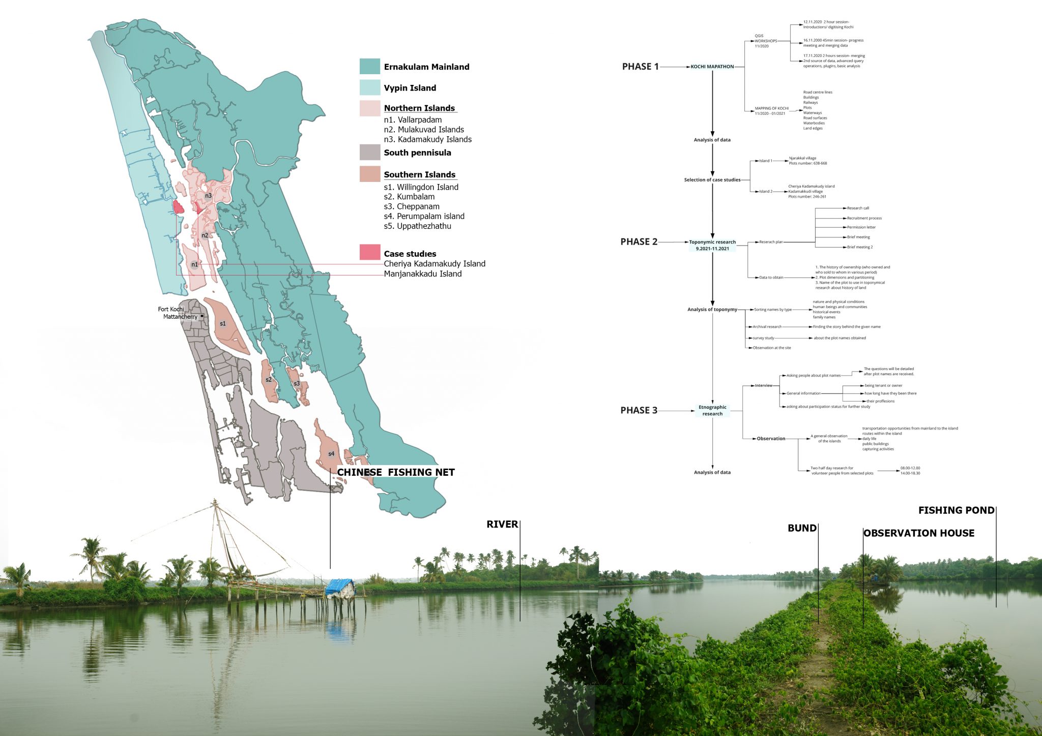
The aim of research is to understand whether the land reclamation process influences the production of space and everyday life practices in the organically and naturally reclaimed settlements on two islands, namely Cheriya Kadamakudy and East Manjanakkad island in Kochi, Kerala.
Land reclamation is a controversial issue and causes social, environmental, political and economic issues in the short or long term. There are many types of reclamation including mine reclamation, wetland reclamation, sea reclamation, arid reclamation, coastal reclamation, etc. These land reclamation types are named differently according to the area to be reclaimed, purpose and techniques and all of them refers to a different kind of expansion. When looked at from the perspectives of urban development, this expansion is called "seaward land reclamation and many countries have applied to seaward reclamation to obtain new industrial, housing and commercial areas. When seaward land reclamation is mentioned, it is generally accepted that it means expansion of the city towards the sea in an artificial way. However, there are also examples where the city naturally expands towards the sea. Kochi has a distinctive pattern of expansion from the mainland to the sea through natural factors which are winds, waves, tides. After natural events or concurrently, the islanders, who mostly make their living by fishing, start to create their own spaces
This research is empirically based, using semi-structured interviews with eighteen islanders
with data collected through “snowball sampling”. Interviews were conducted on two islands.
The research consisted of two main parts including observation and interview. Involvement in
this research covered a period of 2 days. Research was complemented by toponymic research
to map the land transformation in addition to the spatial model created using QGIS.The title
deeds, plot names, transactions and maps of the selected islands in the land registry offices were
examined and clues regarding land transformation were sought
-

Yagmur Burcu Gunes
(she/her)
Yagmur Burcu Gunes is an architect who holds a B.Sc. degree in Architecture from Dokuz Eylul University as a highest-ranked student and an M.Sc. degree in Architectural Design from Istanbul Technical University. While she was doing her master, he started to work as a research assistant at the Department of Architecture in Manisa Celal Bayar University. After that, she obtained a scholarship by the Turkish Government to study abroad. Currently, she is a full-time PhD candidate in Architecture at the Welsh School of Architecture, Cardiff University. She is interested in coastal settlement, informal city, everyday life practices, urban design theories.
yagmurgunbek@gmail.com
Other work by Yagmur Burcu
